| Image Processing Toolbox | |
Coordinate Systems
Locations in an image can be expressed in various coordinate systems, depending on context. This section discusses the two main coordinate systems used in the Image Processing Toolbox, and the relationship between them. These two coordinate systems are described in
Pixel Coordinates
Generally, the most convenient method for expressing locations in an image is to use pixel coordinates. In this coordinate system, the image is treated as a grid of discrete elements, ordered from top to bottom and left to right, as illustrated by Figure 2-6.
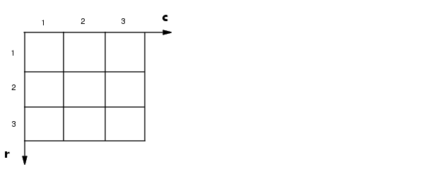
Figure 2-6: The Pixel Coordinate System
For pixel coordinates, the first component r (the row) increases downward, while the second component c (the column) increases to the right. Pixel coordinates are integer values and range between 1 and the length of the row or column.
There is a one-to-one correspondence between pixel coordinates and the coordinates MATLAB uses for matrix subscripting. This correspondence makes the relationship between an image's data matrix and the way the image displays easy to understand. For example, the data for the pixel in the fifth row, second column is stored in the matrix element (5,2).
Spatial Coordinates
In the pixel coordinate system, a pixel is treated as a discrete unit, uniquely identified by a single coordinate pair, such as (5,2). From this perspective, a location such as (5.3,2.2) is not meaningful.
At times, however, it is useful to think of a pixel as a square patch. From this perspective, a location such as (5.3,2.2) is meaningful, and is distinct from (5,2). In this spatial coordinate system, locations in an image are positions on a plane, and they are described in terms of x and y (not r and c as in the pixel coordinate system).
Figure 2-7 illustrates the spatial coordinate system used for images. Notice that y increases downward.
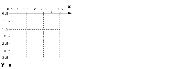
Figure 2-7: The Spatial Coordinate System
This spatial coordinate system corresponds closely to the pixel coordinate system in many ways. For example, the spatial coordinates of the center point of any pixel are identical to the pixel coordinates for that pixel.
There are some important differences, however. In pixel coordinates, the upper-left corner of an image is (1,1), while in spatial coordinates, this location by default is (0.5,0.5). This difference is due to the pixel coordinate system being discrete, while the spatial coordinate system is continuous. Also, the upper-left corner is always (1,1) in pixel coordinates, but you can specify a nondefault origin for the spatial coordinate system. See Using a Nondefault Spatial Coordinate System for more information.
Another potentially confusing difference is largely a matter of convention: the order of the horizontal and vertical components is reversed in the notation for these two systems. As mentioned earlier, pixel coordinates are expressed as (r,c), while spatial coordinates are expressed as (x,y). In the reference pages, when the syntax for a function uses r and c, it refers to the pixel coordinate system. When the syntax uses x and y, it refers to the spatial coordinate system.
Using a Nondefault Spatial Coordinate System
By default, the spatial coordinates of an image correspond with the pixel coordinates. For example, the center point of the pixel in row 5, column 3 has spatial coordinates x=3, y=5. (Remember, the order of the coordinates is reversed.) This correspondence simplifies many of the toolbox functions considerably. Several functions primarily work with spatial coordinates rather than pixel coordinates, but as long as you are using the default spatial coordinate system, you can specify locations in pixel coordinates.
In some situations, however, you may want to use a nondefault spatial coordinate system. For example, you could specify that the upper-left corner of an image is the point (19.0,7.5), rather than (0.5,0.5). If you call a function that returns coordinates for this image, the coordinates returned will be values in this nondefault spatial coordinate system.
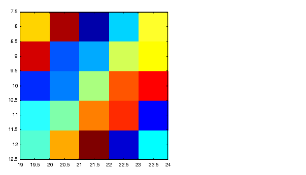
To establish a nondefault spatial coordinate system, you can specify the XData and YData image properties when you display the image. These properties are two-element vectors that control the range of coordinates spanned by the image. By default, for an image A, XData is [1 size(A,2)], and YData is [1 size(A,1)].
For example, if A is a 100 row by 200 column image, the default XData is [1 200], and the default YData is [1 100]. The values in these vectors are actually the coordinates for the center points of the first and last pixels (not the pixel edges), so the actual coordinate range spanned is slightly larger; for instance, if XData is [1 200], the x-axis range spanned by the image is [0.5 200.5].
These commands display an image using nondefault XData and YData.
A = magic(5);
x = [19.5 23.5];
y = [8.0 12.0];
image(A,'XData',x,'YData',y), axis image, colormap(jet(25))
See the reference page for imshow for information about the syntax variations that specify nondefault spatial coordinates.
| | Converting the Graphics File Format of an Image | Displaying and Printing Images | |