SE PACIFIC BL CLOUDS OVER THE EQUATORIAL UPWELLING REGION.
SE PACIFIC BL CLOUDS OVER THE EQUATORIAL UPWELLING REGION
- There is considerable evidence that the subtropical and tropical
climate
is strongly influenced by extensive boundary layer clouds off the
coast of the South American continent. It is therefore imperative
that the processes controlling the development, maintenance and
dissipation of these cloud fields is better understood in order that
their effects can be accurately modelled in coupled ocean-atmosphere
models.
- Strong equatorial upwelling in the eastern Pacific
causes the ITCZ to be displaced away from the equator. For reasons
related to the NW-SE direction of the North and South American
coastlines this displacement results in a northwards-displaced ITCZ.
There is a resulting cross-equatorial Hadley cell which is
thought to be strongly modulated by the presence or absence of
boundary
layer cloud over the cold SST region. It is postulated that the
stratus/stratocumulus cloud can cool the SST in the upwelling region,
thereby strengthening the Hadley circulation. The strengthening cell
increases the subsidence over the cold region which can further
enhance the boundary layer cloud. Potentially, this gives rise to an
instability which is, as yet, poorly understood.
- Crucial to our being able to accurately model the strength of
this feedback is the ability of models to maintain a persistent cloud
deck over the cold regions of the south east Pacific. Currently, this
appears to be a particular problem for many climate models to achieve.
In the north east Pacific boundary layers evolve over
generally increasing SSTs as they move westwards and become the
easterly trades. In contrast, boundary layers in the south east
Pacific stratus region are initially warmed from below as they advect
equatorwards, but then experience a cooling as they pass over the
east Pacific cold tongue (see Fig. 1 below). A very rapid warming then ensues in the
cross-equatorial flow. The dynamical (and possibly microphysical)
processes are therefore somewhat different to stratocumulus transition
regions observed elsewhere. Detailed observations of these clouds are
lacking, a shortfall that the planned 2001 EPIC (East Pacific Investigation of Climate Processes in the
Coupled Ocean-Atmosphere System) observational campaign
seeks to redress.
 The above image shows a snapshot of the cloud optical depth from MODIS
to the west of the
Galapagos Islands (on equator at 91W) together with the TRMM TMI SST
field. The width of the image is 1030 km and the height 1750 km. The
sea surface temperature front just north of the equator is clear and
is
modulated by tropical instability waves. Low level cloud is suppressed
as the boundary layer passes across the equatorial cold tongue but
then forms again after the air has passed over warmer waters. Notice
the
strikingly different morphology of the cloud fields to the north and
south
of the front.
The above image shows a snapshot of the cloud optical depth from MODIS
to the west of the
Galapagos Islands (on equator at 91W) together with the TRMM TMI SST
field. The width of the image is 1030 km and the height 1750 km. The
sea surface temperature front just north of the equator is clear and
is
modulated by tropical instability waves. Low level cloud is suppressed
as the boundary layer passes across the equatorial cold tongue but
then forms again after the air has passed over warmer waters. Notice
the
strikingly different morphology of the cloud fields to the north and
south
of the front.
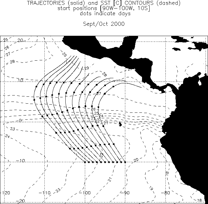 Fig. 1: Climatological trajectories for Sept/Oct 2000 (solid, circles
are spaced 1 day apart).
The trajectories are generated using the
two-monthly mean wind fields taken from the NCEP reanalysis. The
trajectories
are started along the 10S parallel at 1 degree intervals between 100W
and 90W and therefore represent the general advection of the south
east pacific stratocumulus-topped boundary layer. Also plotted are the
mean SST contours for the same period.
Fig. 1: Climatological trajectories for Sept/Oct 2000 (solid, circles
are spaced 1 day apart).
The trajectories are generated using the
two-monthly mean wind fields taken from the NCEP reanalysis. The
trajectories
are started along the 10S parallel at 1 degree intervals between 100W
and 90W and therefore represent the general advection of the south
east pacific stratocumulus-topped boundary layer. Also plotted are the
mean SST contours for the same period.
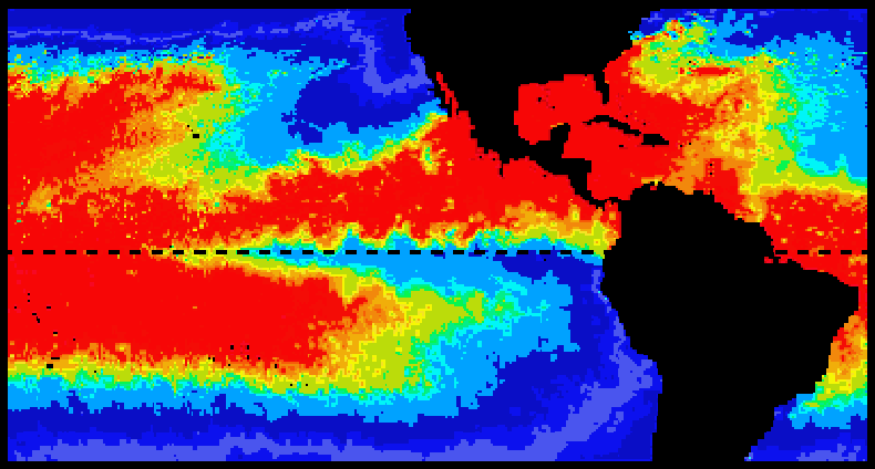 Fig. 2: Sea surface temperature field for July 1984 (from two weeks of
satellite data). Warm water is red and cool water blue. The east
Pacific cold tongue is clearly visible. (Figure taken from the
EPIC
Science and Implementation Plan)
Fig. 2: Sea surface temperature field for July 1984 (from two weeks of
satellite data). Warm water is red and cool water blue. The east
Pacific cold tongue is clearly visible. (Figure taken from the
EPIC
Science and Implementation Plan)
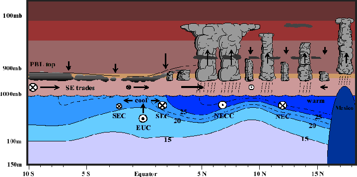 Fig. 3: Schematic of the troposphere across the equator in the cool season
(July-September). (Figure taken from the
EPIC
Science and Implementation Plan)
Fig. 3: Schematic of the troposphere across the equator in the cool season
(July-September). (Figure taken from the
EPIC
Science and Implementation Plan)
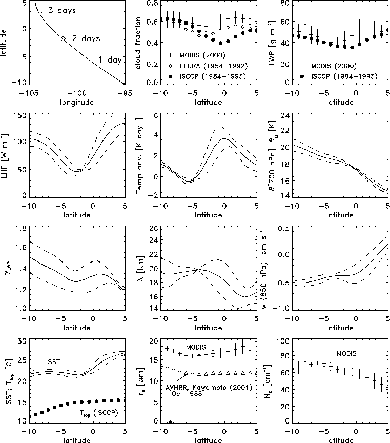 Fig. 4: Time series of observed and reanalysis parameters along the
mean [90W-100W, 10S] climatological trajectory. All data are means (or
medians where stated) from all MODIS scenes during September/October
2000. Error bars show +/- 1 standard deviation of results from the
11 different mean trajectories, and therefore represent the
variability in the mean values across the initial 100W-90W
parallel.
From left to right,
top to bottom:
Fig. 4: Time series of observed and reanalysis parameters along the
mean [90W-100W, 10S] climatological trajectory. All data are means (or
medians where stated) from all MODIS scenes during September/October
2000. Error bars show +/- 1 standard deviation of results from the
11 different mean trajectories, and therefore represent the
variability in the mean values across the initial 100W-90W
parallel.
From left to right,
top to bottom:
- Latitude/longitude plot along trajectory
- Mean cloud fraction (from 256x256km MODIS scenes, 16-17 UTC).
Also shown are ISCCP low cloud amount climatology for the same time
of day and for September/October (1984-1993) and EECRA low cloud
amount (types 1,2,4,5,6,7,8) for all daytime observations cold season
mean 1954-1992
(see EECRA Low
cloud type over the global ocean)
- Mean liquid water path (LWP) (from 256x256 km MODIS scenes). Also
shown is the ISCCP water path taken from the same subset as cloud
amount
above.
- Surface latent heat flux (NCEP)
- Temperature advection (NCEP+Reynolds blended SST)
- Lower tropospheric stability
- Median ratio of (mean LWP to standard deviation of LWP)^2 for
all 256x256 km cloud scenes from MODIS with cloud fraction > 0.1
- Median integral scale (characteristic scale of mesoscale
convective cells) of all cloud scenes with cloud fraction > 0.5.
For method of calculation from MODIS data see
.
- Subsidence speed at 850 hPa (NCEP)
- Sea surface temperature (Reynolds blended product) and cloud
top temperature (ISCCP, see under cloud fraction above for details)
- Mean cloud particle effective radius (MODIS). Also shown is the
AVHRR retrieval data for October 1988 (a negative cold tongue index
(CTI)
year as is 2000)
from Kawamoto et al. (2001)
- Mean effective droplet concentration (MODIS)
- Questions:
- Why do the ISCCP and MODIS cloud amounts diverge north of 4S-5S?
Taking only ISCCP data from negative CTI years (e.g. 1988) does not
markedly improve the agreement. For the particular analysis of MODIS
scenes presented here, it is
required that the mean cloud-top temperature
in the 256x256km scene is greater than 270K. This is because a known bug in
the MODIS calibration/processing routines leads to very noisy cloud
top temperature data. Rejected
scenes due to cold cloud presence runs at around 20-25% at 5S increasing
to 40-50% at 5N. However, cloud top temperature in MODIS scenes
analysed has some inaccuracies which result in warm clouds being
classified
as cold clouds. If the MODIS scenes rejected due to misclassification
of cloud top temperature have lower cloud fractions than those
correctly classified then this could suggest a positive bias in the
MODIS cloud fraction. My thoughts here are that MODIS is more likely
to
misclassify clouds when the true cloud top temperature is close to
273K and broken. However, it does not appear that, in the region of
interest, there is a significant correlation between mean cloud top
temperature and cloud fraction. Hopefully, this issue will be resolved
when the accurate cloud top temperature data from MODIS becomes
available.
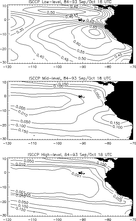
In addition, ISCCP high and medium
cloud amounts along the trajectories south of 5N are less than less
than
1% and 5% respectively
(SEE
FIGURE),
and so it is unlikely that ISCCP low cloud
amounts will be strongly affected by the presence of cloud above the
boundary layer.
The form of the EECRA low cloud amount-latitude curve
is similar to that from MODIS, with initially high values at 10S
falling to a minimum at around 3S-5S and rising to a peak at 2N-3N.
They are 0.05-0.07 lower than MODIS values between 7S and 5N, but
this may reflect the fact that EECRA cloud amounts are averaged over
the entire cold season (July-November inclusive) while the peak cloud
amount for this region is found in September-October.
EECRA cloud amounts are derived
from
all daytime observations while MODIS are taken at around 10-11am local
time. It is interesting that all three measures agree very well
at 10S. The diurnal cycle (the amplitude of the first harmonic)
of low cloud amount from ISCCP for the same
location is some 5-15% with a peak cloud amount at around 2am local
time (Rozendaal et al. 1995). A simple sinusoidal model of
cloud amount diurnal variation using this phase
gives 10-11am cloud amounts that are very similar to the daylight
mean cloud amounts (which are assumed here to be 7am-7pm local
time). This suggests that the diurnal cycle may not be responsible for
the difference between EECRA and MODIS cloud amounts.
Rozendaal et al. show that ISCCP VIS/IR (not used here) retrievals of cloud amount
generally
exceed those of ISCCP IR (used here) by approximately 0.1-0.2 in the
region of interest, which could explain the discrepancy. All three
measures
of cloud amount agree very well at the start of the trajectories and
so the VIS-IR ISCCP difference would need to be small here if this
particular
effect is to blame. It is unlikely in the region of interest that the
presence of fog or very low cloud (such as that under sub 500 m
inversions)
would be responsible for the VIS-IR difference. The
presence of smaller cloud elements around the equator could be
responsible. There is some evidence from the MODIS dataset that the
clouds
become smaller to the north of 5S (see integral scale in figure),
although
the decrease does not appear to be large (<20%).
- Why are MODIS effective radius means around 4-5 microns larger
than
the corresponding AVHRR climatology values? I don't think that this
can
be explained using the diurnal cycle of effective radius, and probably
is more likely to represent early retrieval problems with MODIS. Given
this, it is probably unwise at present to rely upon MODIS effective
radius
retrievals.
Kawamoto, K., Nakajima, T. and Nakajima,
T. Y., 2001: A global determination of cloud microphysics with AVHRR
remote sensing, J. Clim., 14, 2054-2068.
Rozendaal, M. A., C. B. Leovy and S. A. Klein, 1995: An Observational
Study of Diurnal Variations of Marine Stratiform Cloud.
J. Clim., 8, 1795-1809.