
The thermohaline circulation
Over most of the world ocean the water
in the mixed layer is less dense than the water below and convection is
suppressed. Notable exceptions are the far North Atlantic along
the edge of the Arctic pack ice and in the Weddell Sea along
the edge of the Antarctic pack ice. In these regions the
surface waters can become sufficiently cold and saline to enable them to
sink to the bottom of the ocean.
This oceanic convection is upside down
relative to the convection in the atmosphere. Instead of involving
buoyant, rising plumes of moist fluid, it involves sinking plumes of cold,
saline water that is denser than the surrounding water. We saw
in class a demonstration illustrating convection in water (2 beakers with ice floating at the top or at the bottom).
Formation of bottom water
How does the surface water in these regions
become cold and saline enough to sink to the bottom? Two processes
are responsible: evaporation and freezing.
Evaporation systematically removes fresh water from the surface waters of the ocean, leaving the residual water more saline. In changing phase from liquid to vapor, the evaporating air molecules also remove heat from the residual ocean water that will later be realized as latent heat of condensation in clouds. The rate of evaporation is particularly high over the North Atlantic and the Weddell Sea, where cold polar air masses flow out over warm ocean waters, creating conditions that favor vigorous (atmospheric) convection. This atmospheric convection efficiently removes heat and water vapor from the sea surface by carrying them upward in buoyant plumes. The surface air that ascends in the plumes is replaced by drier air from above, that is quickly moistened by conduction when it comes into contact with the water surface. But evaporation alone is rarely sufficient to make the surface water of the ocean dense enough to sink.
It is through the process of freezing, as occurs during winter along the edge of the polar sea ice, that the surrounding water acquires the additional density that makes it negatively buoyant. Although the ice forms from salt water, the ice itself is composed entirely of fresh water. In the process of freezing, salt molecules are systematically rejected. Through this process of 'brine rejection', freezing increases the salinity of the residual sea water that isn't incorporated into the ice, thereby increasing the density of patches of water near the edge of the ice to the point at which they sink to the bottom. Oceanographers refer to this process as 'the formation of bottom water'.
The Thermohaline 'Conveyor Belt'
The newly formed bottom water carries
with it the properties that it had when it was up at the surface.
It is close to 4°C (39°F), the temperature at which the density
of water is highest (i.e., if water at 4°C is either cooled or warmed,
it expands; water at the freezing point is less dense than water at 4°C).
This circulation pattern has been inferred largely through oceanic tracers.
Figure 1 shows water 'age' (defined as the time elapsed since the water
was last at the surface) at 3 kilometers depth, based on Carbon-14 tracer
data. It shows that the youngest deep water occurs around the Greenland,
Labrador and Weddell Seas, where the deep water forms. The water becomes
progressively older as it travels along the western boundary of the Atlantic,
to the Indian and, finally, into the Pacific ocean, where the oldest deep
water masses in the world ocean are found.
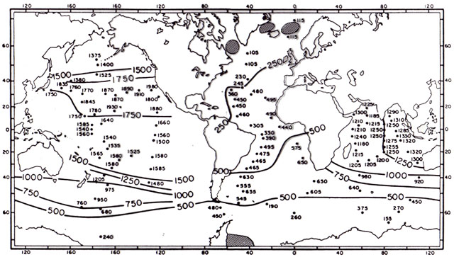
Fig 1. Radiocarbon ages for deep-sea
water. Dots indicate station locations and ages of water taken from 3 kilometers
depth. Shaded areas indicate sites of deep water formation. (Broecker,
1985)
Ocean chemists can also estimate the date when bottom water in various parts of the ocean was formed by measuring the concentration of dissolved freon (chlorofluorocarbon--CFC) gases), the first of which began to be manufactured during the 1950's. From these measurements North Atlantic bottom water has been tracked over the past few decades as it makes its way southward in the bottom branch of the thermohaline circulation. To picture how this circulation affects the remainder of the world ocean, oceanographer Wallace Broecker has used the analogy of a global scale 'conveyor belt' as pictured in Fig. 5-14 of the text.
Bottom water doesn't form over the North Pacific because the water is too fresh to sink, even along the ice edge. Evidently, there's just a little more precipitation relative to evaporation over the Pacific basin and the river drainage basins flowing into it than there is over the Atlantic.
The strength of the thermohaline circulation
is determined by the rate of sinking of negatively buoyant plumes in the
far North Atlantic which, in turn, depends upon the density of the water
in that region. If the ocean in this region were capped by a thin
layer of water that was too fresh to become dense enough to sink, the thermohaline
circulation would shut down. Among the processes that could freshen
the surface waters in this region are an increase in runoff of fresh water
from rivers (like the St. Lawrence) that flow into this region; enhanced
melting of Arctic sea-ice and/or the Greenland continental ice sheet; or
a local increase in precipitation or decrease in evaporation due to a
change in atmospheric wind patterns.
The impact of Ocean Circulation on Climate
The wind driven subtropical gyres transport transport warm water poleward on the western sides of the oceans and warmer water equatorward on the eastern side. The exchange of equal amounts of water containing different amounts of heat, results in a net poleward transport of heat, which supplements the poleward heat transport by atmospheric motions and helps to even out the temperature contrast between the tropics and the polar regions
The thermohaline circulation is most intense
over the North Atlantic, the primary region of bottom water formation.
Surface waters flow northward, cooling as they approach the Arctic.
Eventually they sink in negatively buoyant plumes, and subsequently return
to lower latitudes as bottom water. At a
latitude of, say 40°N, relatively
warm water is flowing northward in the upper branch of thermohaline circulation
near the ocean surface and an equal mass of much colder bottom water is
flowing southward. The northward flowing surface water carries with
it more heat than the southward flowing bottom water. This exchange
of equal masses of water results in a net northward flux of energy.
In the North Atlantic the wind driven subtropical gyre and the thermohaline circulation transport relatively comparable amounts of energy poleward and together they transport roughly half as much energy poleward as the atmospheric circulation does. The wind driven circulation accounts for the shape of the surface currents but the thermohaline circulation contributes substantially to the strength of the Gulfstream. If the thermohaline circulation were to shut down, the Gulfstream would weaken considerably, the poleward heat transport would decrease, and the winters in Northern Europe, which are currently remarkably mild for the latitude, would be much colder (as apparently was the case during the 'Younger Dryas' period 12,000 years ago that will be discussed in class in 2 weeks).
Last
Updated:
10/25/2001