
The marine biosphere; Wind driven ocean currents
1) The marine biosphere
Photosynthesis by microscopic organisms
known as phytoplankton is the base of the food chain that fuels the marine
biosphere. Phytoplankton are 'grazed' upon by microscopic animals
known as zooplankton which, in turn, are the food for the next higher links
on the food ladder, and so on.
Phytoplankton thrive only within the uppermost layer of the oceans where sunlight is available. Sunlight in the visible part of the spectrum (and especially the warm colors) is strongly absorbed by water. Hence, the sunlit 'euphotic zone' is restricted to the uppermost few tens of meters. Some creatures are able to live at greater depths, but nearly all the primary production of 'biomass' (i.e., plant matter in the bottom rung of the food ladder) takes place within the euphotic zone.
Phytoplankton also require nutrients (phosphorus, iron and other chemical species). Plankton 'blooms' would use up all the available nutrients in the euphotic zone within a matter of days if there were no way of replenishing the supply. Plankton and other living creatures that spend most of their lifetimes in the euphotic zone produce fecal matter that sinks to deeper layers and they eventually die and their remains sink into the darkness below. Fecal matter and dead organisms eventually decompose, but the freed up chemical nutrients do not become available to support the next generation of biomass until the ocean circulation lifts them back up into the euphotic zone. Hence, marine life tends to be concentrated in zones of 'upwelling' where nutrient rich water from below the euphotic zone emerges back into the sunlight.
The chlorophyll in the living tissue of
phytoplankton imparts a greenish color to sea water in regions of strong
primary productivity. The distinction on color is visible to the
naked eye, and it is highly visible when the surface of the ocean is scanned
with an instrument that responds strongly to green light. This is
the principle behind the design of NASA's
SeaWIFS instrument. Below are some of the images we looked at
in class. They show the concentrations of chlorophyll in the oceans
(which reflects marine productivity) as well as vegetation on land through
the four seasons.
|
|
|
 |
 |
|
|
|
 |
 |
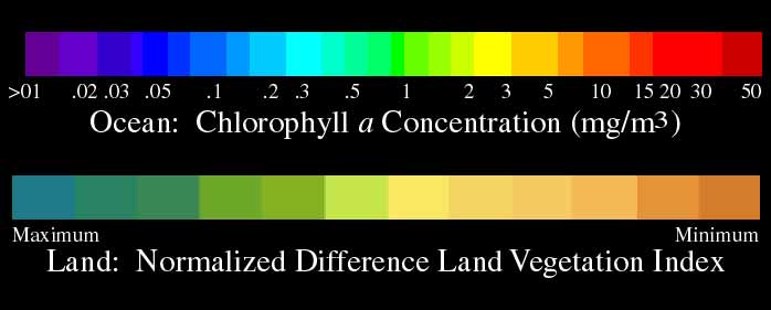 |
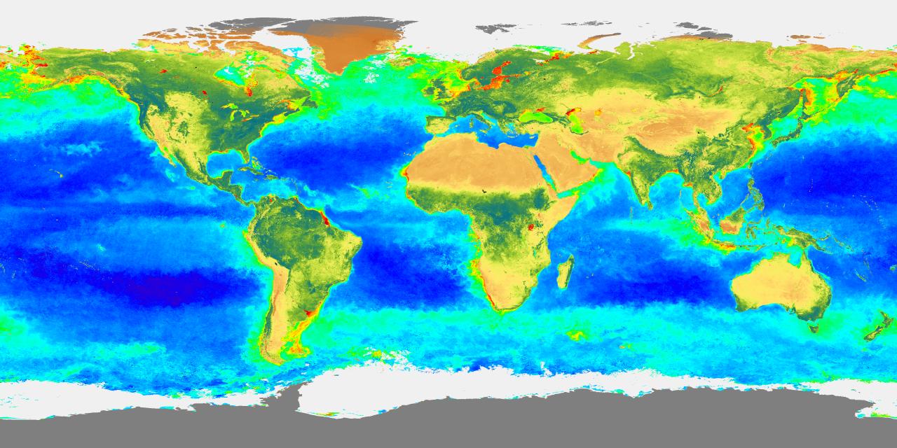
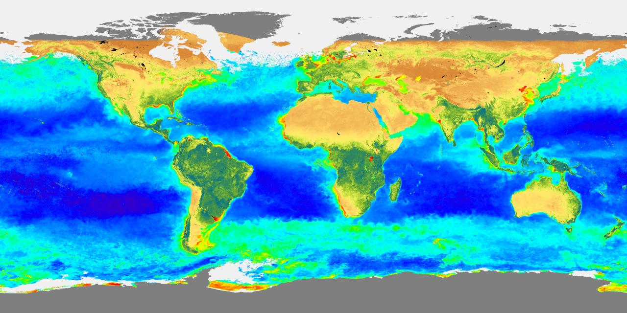
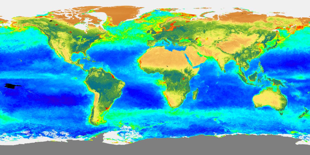
Fig. 1. SeaWIFs images of the global biosphere
in fall, winter, spring and summer. Click on the images to see larger versions
of these images. More images can be found at: http://seawifs.gsfc.nasa.gov/
SEAWIFS/IMAGES/SEAWIFS_GALLERY.html |
Areas of the oceans that are light blue-green correspond to waters with high concentrations of phytoplankton and thus high productivity of the biosphere. Dark blue areas and the "deserts" of the oceans, without much productivity.
Upwelling areas (nutrient rich areas with many phytoplanton) tend to be concentrated within
- (a) regions where the wind and ocean currents circulate 'cyclonically' (in the same sense as the Earth's rotation: counterclockwise in the Northern Hemisphere and clockwise in the Southern Hemisphere); these areas show up clearly in the SeaWIFS images above (North Atlantic and North Pacific Oceans; as well as high latitude ocean waters in the southern hemisphere)
- (b) in certain coastal regions
- (c) and along the equator wherever winds blow from east to west (close to the ITCZ).
The reasons for this will be discussed
below in the section on the wind driven ocean circulation. These
upwelling regions show up clearly in the SeaWIFS imagery. They are
the sites of the world's most productive fisheries.
2) The wind driven ocean circulation
The surface winds over the oceans tend to drag the surface waters with them. In the Pacific and Atlantic, where there are well defined northeasterly and southeasterly trades, the surface currents in the tropics are westward, and over the westerly wind belt from 40 to 60 degrees latitude, the prevailing currents are eastward. The continents block the eastward and westward currents, thereby causing the surface waters to circulate around anticyclonic (clockwise in the Northern Hemisphere; counterclockwise in the Southern Hemisphere) gyres, centered at subtropical latitudes as shown in Fig. 5-2 and 5-3 of the text. At higher latitudes there are smaller gyres that circulate in the opposite (cyclonic) sense. The surface currents over the Indian Ocean is not as distinct because the winds that drive it reverse with the seasons.
The 'dragging' of the surface waters by
the winds implies a transfer of momentum from the atmosphere to the oceans:
hence the term, 'wind driven'. The actual momentum transfer is accomplished
through the generation and dissipation of surface waves, which move in
the same direction as the wind. The up and down motions caused by
surface waves extend to a depth of only a few tens of meters, but the wind
driven currents extend deeper into the ocean due to processes related to
the Earth's rotation.
 |
 |
The Coriolis force due to the Earth's rotation acts to deflect the surface currents toward the right in the Northern Hemisphere and toward the left in the Southern Hemisphere. [For an explanation of the Coriolis Force see p. 82-84 of the text. You won't be required to learn it for this course.] The surface waters circulating around the subtropical gyres are deflected inward toward the center of the gyres, as pictured in the left panel of the figure above. The accumulation of surface waters in the interior of the gyre thickens the mixed layer and depresses the thermocline (as shown). It also causes sea level to rise (as pictured in figure 5-5 in the text on page 83) but this effect is very small compared to the depression of the thermocline. The depression of the thermocline keeps the nutrients lower in the water column than they are elsewhere in the world ocean. Hence, the marine biosphere is relatively inactive in the subtropical gyres: the waters are relatively clear (chlorophyll free) and show up dark blue in the SeaWIFS imagery.
For the same reason, the surface waters circulating in the cyclonic gyres on the poleward side of the westerly wind belts is deflected outward, pulling the thermocline (and the nutrients) upward in the center of the gyre, which tends to enhance the production of chlorophyll (and fish) in these regions. The tight cyclonic circulations in hurricanes are sometimes strong enough to bring the thermocline right up to the surface within a matter of a day or two, leaving behind a patch of conspicuously cold water.
Very strong coastal upwelling is observed in regions where the surface winds circulating around the subtropical anticyclones blow parallel to the coastlines. One of these regions is the coast of Oregon and Northern California during summertime. The northerly (north to south) wind around the eastern side of the subtropical (Pacific) gyre drives a strong north to south coastal current which is deflected toward the right-- away from the coastline. As the surface water drift offshore, they are replaced by cold, nutrient rich subsurface waters. In a typical summer there may be intervals of a week or two when the northerly winds weaken and the upwelling stops. Within a few days the surface nutrients are used up, the biosphere goes dormant and the quality fishing abruptly declines. At such times, those whose livelihood depends on fishing watch the weather forecasts for a sign of the return of the northerlies. Other area where coastal upwelling occurs include the coasts of northern Chile and Peru and West Africa.
Equatorial upwelling occurs wherever the winds blow from the east. Surface waters just to the north of the equator are deflected toward the north and surface waters just to the south of the equator are deflected toward the south. As the surface waters drift away from the equator (in both directions) the equatorial thermocline bulges up, close enough to the surface so that mixing from the surface waves can stir nutrients upward into the euphotic zone where phytoplankton can feed on it. Hence the equatorial belt shows up bright green in the SeaWIFS images. The zone is narrow because the phytoplankton growing in the upwelled water go through their life cycle in just a day or two-- not long enough for the upwelled water to diverge more than a few tens of km from the equator.
Last
Updated:
10/25/2001