
The poleward transport of heat by atmospheric motions
Let's consider a simplified 'Earth like' planet which has net radiative heating at the Tropics and cooling at the poles. To deduce what the climate of such a simplified planet would look like we rely on experiments that have been performed with numerical models of the atmospheric component of the climate system. When realistic land-sea geometry, mountains, and seasonal changes in solar heating are prescribed in these models, they yield quite realistic simulations of the observed climate. Therefore the model simulations of our idealized Earth-like planet should have some credibility.
Simplified Earth-like planet with net heating at the tropics
When such a model atmosphere is 'turned
on', starting from a state of rest (no winds, horizontally uniform temperatures)
the tropics warm and the polar regions cool in response to the imposed
latitudinal contrast in the sun's heating, which is prescribed in a way
that mimics that in the real atmosphere. Let's assume that
when the heating is first turned in, the atmosphere is not rotating.
The ensuing sequence of events is depicted schematically in Fig. 1:

Fig. 1 Schematic depiction
of the development of the atmospheric circulation,
starting from a state of rest.
The equator-to-pole contrast in incoming solar radiation cause the tropics to warm and the high latitudes to cool. The temperature changes are largest in the troposphere, which extends to about 10 km. As the tropical troposphere warms, thermal expansion causes the air at the 10 km level to bulge upward relative to the cooling air at the higher latitudes, as represented by the heavy arrows in panel (a) of Fig. 2. Hence, the mass of air weighing down on the 10 km level increases in the tropics and decreases in high latitudes. The uneven weight of the air gives rise to a pressure gradient, which pushes the air poleward, as depicted in panel (a) of the figure.
The poleward flow of air in the upper troposphere causes air to 'pile up' at the higher latitudes. The increasing weight of the overlying air column causes sea level pressure to rise at high latitudes, while the sea-level pressure at low latitudes decreases by an equal amount. The equator-to-pole contrast in sea-level pressure drives a compensating low level flow toward equator as depicted in panel (b) of the figure. Together, the poleward high level flow and the low level equatorward flow make up a giant circulation cell extending all the way from equator to pole, with rising motion in the tropics and inking at high latitudes, as shown on the right hand side of panel (b). We can imagine that the equatorial belt, where the air in the cell is rising should be wet, and the polar regions, where air is sinking should be dry.
In this manner, differences in solar heating causes equator-to-pole movement of air. We will now see how the rotation of the Earth causes East-West movements.
Simplified Earth-like planet with net heating at the tropics + rotation
Now let's turn on the rotation and see
what happens. Once the atmosphere starts to rotate, the conservation
of angular momentum begins to generate a component of the flow that circulates
around the Earth's axis as shown in panel (c). In the Northern Hemisphere
winds coming from the pole will appear to come from the Northeast, while
in the Southern Hemisphere winds coming from the pole will appear to be
coming from the SouthEast. This 'zonal' flow arises as a result of
the Earth's rotation and is called the Coriolis effect. Some simple
principles apply to this effect:
(1) it is directly proportional to the
wind speed on the rotation planet (i.e., it affects only moving objects)
(2) it is proportional to rotation rate (i.e., to have a Coriolis force,
the planet has to be rotating (3) its horizontal component, which
is what we care about, is proportional to the sine of the latitude (i.e.,
it is zero on the equator and increases with latitude) (4) it is
directed to the right of the wind in the Northern Hemisphere and to the
left of the wind in the Southern Hemisphere.
We can think of the Coriolis force as deflecting the poleward flow at the 10-km level toward the right in the Northern Hemisphere (left in the Southern Hemisphere) to create a westerly wind component and the easterly flow at the earth's surface toward the left in the Northern Hemisphere (right in the Southern Hemisphere) to create an easterly wind component.
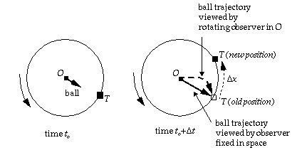
In class we illustrated this by having
an observer position herself at the North pole and throw a ball at target
T (see Fig. 2 below). It takes a certain time for the ball to reach
the target, during which time the target will have moved a certain distance
as a results of Earth's rotation, causing the ball to miss the target.
The rotating observer at the North Pole (moving with the Earth) does not
perceive the target as having moved, because her frame of reference is
moving the same way. However the shot missed. From the perspective
of the observer, the ball has been deflected to the right of the target.
We can repeat the same type of thought
experiment by positioning the observer at a given latitude in the Northern
Hemisphere and throw the ball at a target North of her position. The result
will be the same: the ball will appear to have been deflected to the right
of the target.
Example: movie of a ball rolling
across the surface of a rotating merry-go-round.
Quicktime (2.0M)
MPEG (0.9M)

As the heating in the tropics and the cooling at lower latitudes continue, the equator-to-pole temperature contrast gradually increases, and so does the strength of the upper level westerlies. The resulting circulation in panel (c) resembles the observed circulation in some ways (i.e., like the Earth it has tradewinds and an equatorial rain belt, but it has no midlatitude westerlies and the deserts are in high latitudes rather than in the subtropics. Does the model have it wrong? No, we just have to be patient.
Development of extratropical cyclones
After a few weeks of simulated time, the
behavior of the model suddenly changes. At that point, the equator-to-pole
temperature gradient reaches a critical value which is strong enough to
support the development of extratropical cyclones. They develop as barely
perceptible undulations in the westerlies, but within a few days of simulated
time they intensify to the point where they begin to change the entire
character of the flow by transporting heat, water vapor and angular momentum
poleward. The specifics of how these changes come about is beyond
the scope of these lecture notes, but the overall effects are:
(1) the extratropical cyclones become the primary mechanism for the poleward
transport of heat in midlatitudes. Once they develop they prevent
the further buildup of the equator-to-pole temperature gradient.
Whenever the gradient gets too strong, the storms intensify and weaken
it. (2) the extratropical cyclones disturb the upper level flow in
such a way as to take angular momentum out of the tropics and deposit it
in midlatitudes. This poleward transport of angular momentum is responsible
for the maintenance of the belt of westerly winds at the Earth's surface
in midlatitudes (3) the extratropical cyclones are responsible for the
sinking motions in the subtropics which favor desert conditions and for
a secondary maxima in rainfall around 55 N and 55 S.
Panel (d) of Fig. 1 depicts the atmospheric circulation as modified by the extratropical cyclones. Note how the equator-to-pole circulation cell in the previous panel retreats to the tropics. It is known as the 'Hadley cell'. The tradewinds undergo a similar shrinkage as a result of the development of the extratropical cyclones. The desert belts separate the trades from the midlatitude westerlies.
Last
Updated:
10/22/2001