
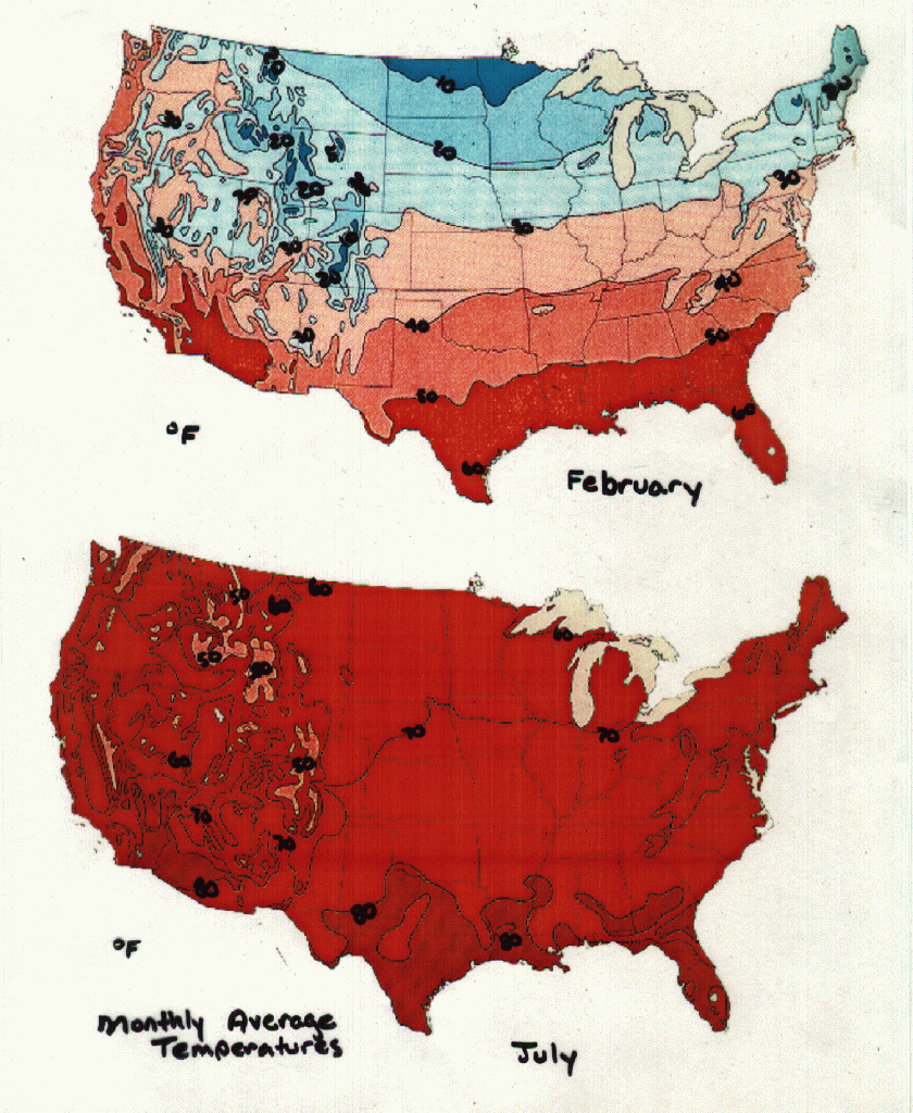
Comparing the temperatures, I noticed that a common
trend, not unlike the West Coast, is that the temperature gets warmer as
you travel south. The northern most station, Bangor, Maine, the coldest
station by far. I chose this station in particular because it is easy to
compare to Seattle. Bangor has nearly the same elevation and latitude as
Seattle, and it lies near the coast, but it has very different climate
characteristics. The mean January snowfall in Bangor is three times that
of the average snowfall over the whole year in Seattle. The cold temperature
on the East Coast is due to the winds. In the winter, the westerly winds
blow warm moist air onto the West Coast, which makes it rain so much. Since
land cools and heats more than the ocean does, the land is much colder
than the ocean during the winter. As these westerly winds are blown over
Canada and the northern United States and because the land is cold, the
air cools drastically. By the time the moisture in the air gets to the
East Coast, it is cold enough to produce much snow instead of rain.

The precipitation patterns of the East Coast behave
differently from the West Coast as well. On the East Coast you will notice
that the farther south you travel, the more precipitation there is. In
Miami, on the southern tip of Florida, there is more than twice as much
rain in June (on average) as there is in Bangor, Maine. This also is due
to the direction of the winds. In the winter, the winds come from the west,
across the continent. When they reach the ocean, they circle around in
a clockwise direction and come back inland south of Florida, near Mexico.
In the summer, the wind pattern is the same, except it is shifted northwest.
The wind current circles in a clockwise motion, but at this time of year,
it circles just off the coast, so that the wind coming from the southeast
follows the East Coast northward. The warm moist air that comes from the
ocean is deposited on the land. Since Florida is farther south, the air
is warmer and it holds more moisture. As it travels northward, it is getting
farther from the equator so the air cools off and can't hold as much moisture,
which is why it rains less as you travel north on the East Coast.
| Bangor, ME | Springfield, IL | Roanoake, VA | Montgomery, AL | Miami, FL | Seattle, WA | |
| Elevation | 151 ft | 617 ft | 1174 ft | 200 ft | 13 ft | 125 ft |
| Mean Annual Temp. | 44.53° | 52.58° | 56.02° | 64.87° | 76.14° | 53.28° |
| Mean Jan. Temp. | 17.71° | 24.54° | 34.93° | 45.88° | 67.70° | 41.80° |
| Mean June Temp. | 62.99° | 72.99° | 71.86° | 78.73° | 81.53° | 61.66° |
| Mean Annual Precip. | 39.8" | 35.42" | 41.04" | 54.09" | 57.95" | 36.98" |
| Mean Jan. Precip. | 3.21" | 1.62" | 2.98" | 4.95" | 2.16" | 5.16" |
| Mean June Precip. | 3.51" | 3.41" | 3.54" | 4.00" | 9.48" | 1.48" |
| Mean Annual Snow | 65.92" | 25.05" | 24.34" | 0.47" | 0.0" | 6.31" |
| Mean Jan. Snow | 18.08" | 6.90" | 7.29" | 0.2" | 0.0" | 6.18" |
Precipitation
Looking at the Rocky Mountains in terms of precipitation, we see the affects of a Rain Shadow. At least this is the pattern for the winter months. As you can see on the precipitation map of January the west side of the Rockies recieves much more precipitation than the east side and the Plains as well. The map for July's precipitaion shows a different story. This pattern is largely due to the fact that the Gulf of Mexico swirls warmer and moister weather systems into the Plains and onto the eastside of the Rockies. As a whole the Plains experience low counts of precipitation and humidity with the major source of precipitation coming from the Gulf of Mexico during the spring and summer months. The southern Plais recieve 15-25 inches of precipitation annually while the northern Plains recieve only about 12-15 inches annually.

Another characteristic of the Plains is the trmendous winds and sudden changes in temperature. A distinctive winter phenomenon of the Western Great Plains is the Chinook- a warm wind that blows down the eastern slope of the Rockies creating a possible temperature rise of 30-40 degrees F in a short period of time.
Temperatures
the temperatures of the Rockies is nearly all directly corrolated with it's elevation, with the only exception being the Southern Rockies in Arizona and New Mexico which recieve weather systems from the Gulf of Mexico and the coast of California which make them warmer. Over much of their expanse, The Plains have cold winters and warm summers. And like it's precipitation the Plains are affected by the westerly winds and winds prevailing from the North (Canada and Alaska)
Tornados
It's because of this warm, moist air from the Gulf of Mexico (which
begins to penetrate the Gulf states in February)that collide with contrasting
cool, dry air from the north and northwest. A squall line of severe local
storms develope along this boundary and a family of tornados can be born.
The spring and summer provide five times as many tornados than in fall
and winter.

In the Pacific Ocean, one of the things that creates the conditions typical for this ocean is the topography of the ocean itself in the area immediately surrounding the coastline, the bottom of the ocean has much more of a sudden "drop-off" than other bodies of water. The Gulf of Mexico, for example, has a relatively shallow shelf that extends out quite a great distance from the coastline. Since the Pacific Ocean has this depth up close to its coast, the water in this area has much more of a temperature gradient. This means that the sunlight that is coming in contact with the surface of the water has to be "spread out" to a much greater depth, therefore the water at the botttom of the ocean is much colder than the water at the surface. This colder water at the bottom allows nutrients, such as very small organisms, to thrive and flourish in a very interesting way. A property of liquids that chemists often take advantage of is that the colder a liquid is, the more gas is able to dissolve in it. This means that the cold water of the Pacific is able to have more oxygen dissolved in it, making it an ideal place for these organisms to live. With the help of the tradewinds, these nutrients are drawn upward in a process called upwelling, and distributed throughout the water. This makes an excellent base for a thriving food chain in the ocean.
The mountains that extend down the coastline have an effect on the weather to both the east and the west of those mountains. As warm air containing water vapor from the Pacific moves eastward over the land, it comes in contact with the mountains causing it to rise upward along the face of the mountains. As it rises upward, the air cools and the water vapor condenses into droplets. When these droplets become heavy enough, they fall back to the Earth in the form of rain or snow. The majority of the precipitation will fall to the west of the mountains creating what is called a rain shadow on the east side. This mechanism is largely responsible for the weather of the west coast, so cities such as Seattle, have a great deal of rainfall with temperate summers and winters, while areas like Death Valley see little to no precipation and extreme temperature conditions from season to season.
The presence of the Pacific Ocean and the coastal mountain ranges create
unique and interesting weather patterns. There are such a wide range of
variables for things such as altitude, rainfall, temperature, etc. that
it makes this region an interesting one to study.

|
|
|
|
|||
| City |
|
|
|
|
|
| St. John's |
|
|
|
|
|
| Charlottetown |
|
|
|
|
|
| Halifax |
|
|
|
|
|
| Fredericton |
|
|
|
|
|
| Quebec |
|
|
|
|
|
| Montreal |
|
|
|
|
|
| Ottawa |
|
|
|
|
|
| Toronto |
|
|
|
|
|
| Winnipeg |
|
|
|
|
|
| Regina |
|
|
|
|
|
| Edmonton |
|
|
|
|
|
| Calgary |
|
|
|
|
|
| Vancouver |
|
|
|
|
|
| Victoria |
|
|
|
|
|
| Whitehorse |
|
|
|
|
|
| Yellowknife |
|
|
|
|
|
| Aklavik |
|
|
|
|
|
| Resolute |
|
|
|
|
|
| Juneau |
|
|
|
|
|
| Anchorage |
|
|
|
|
|
| Fairbanks |
|
|
|
|
|
| Barrow |
|
|
|
|
|

